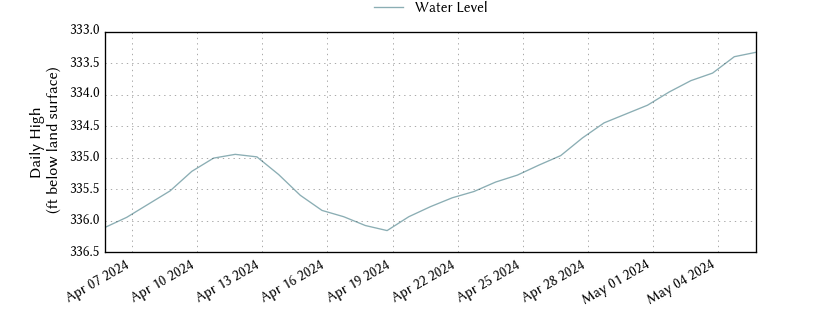
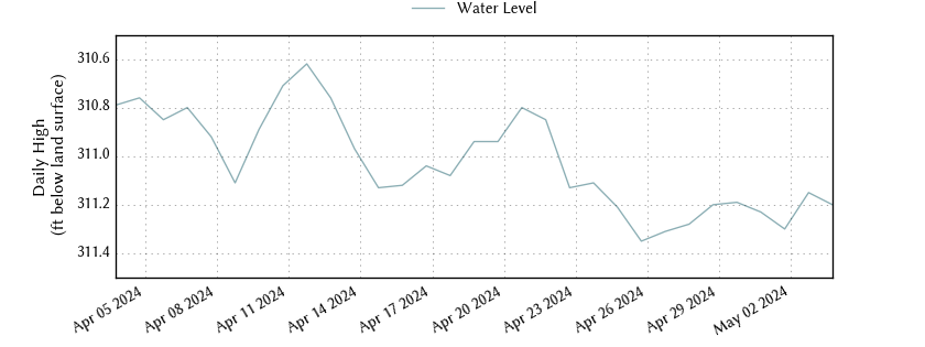
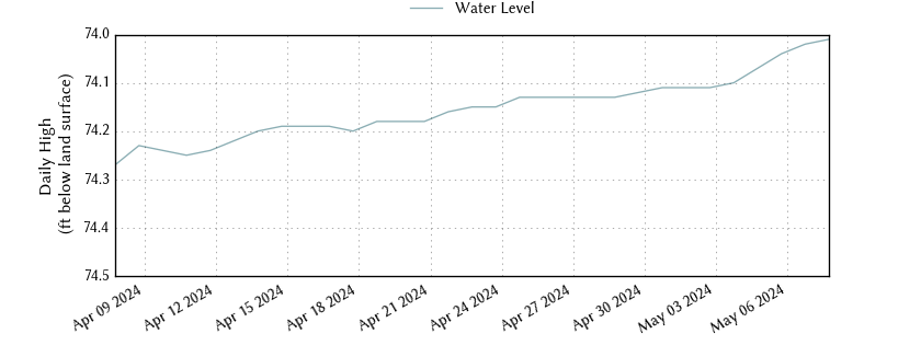
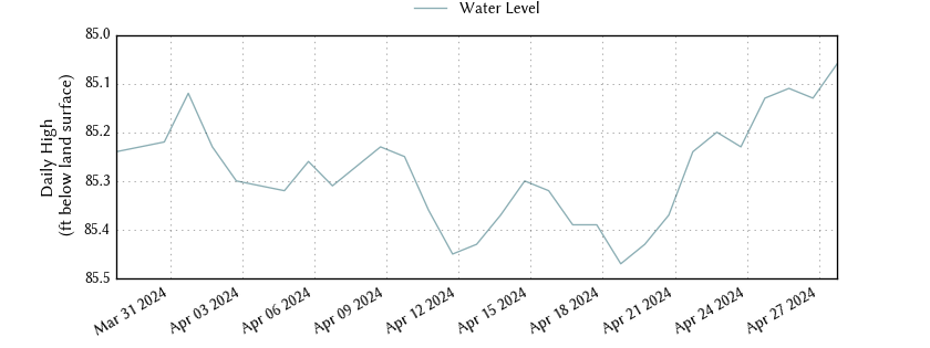
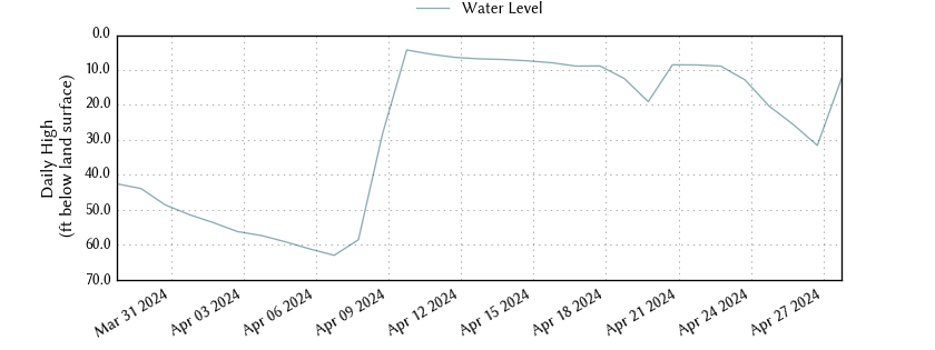
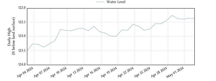
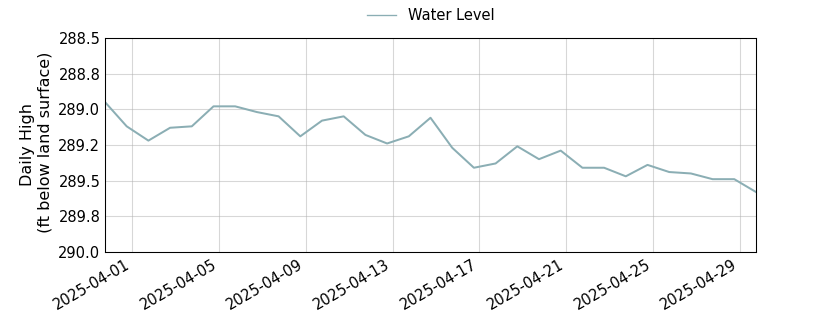
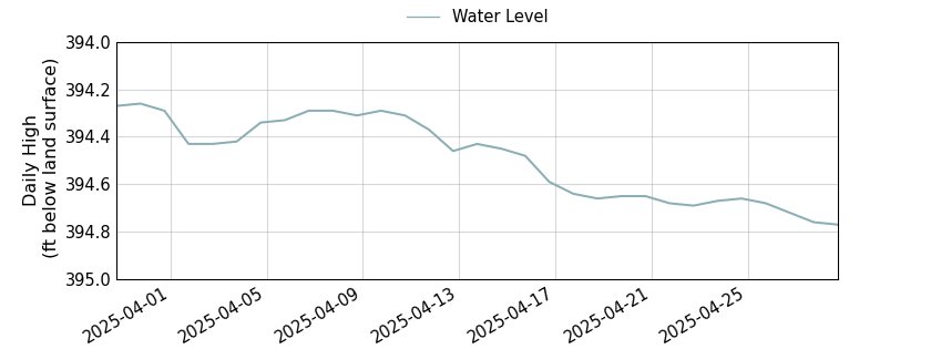
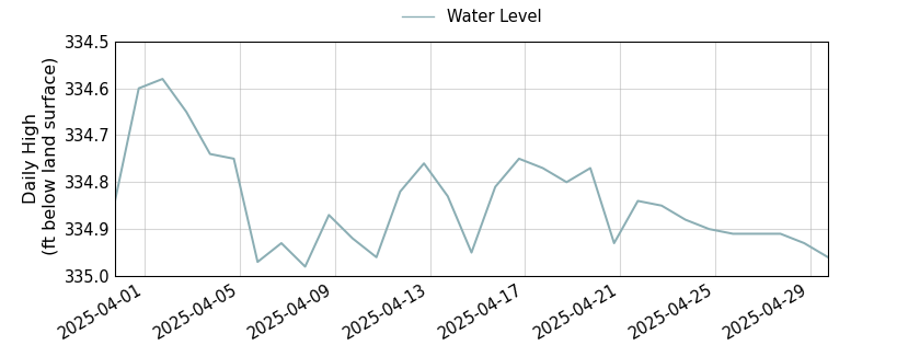
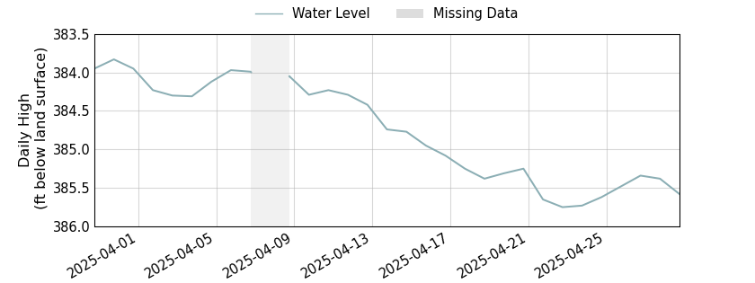
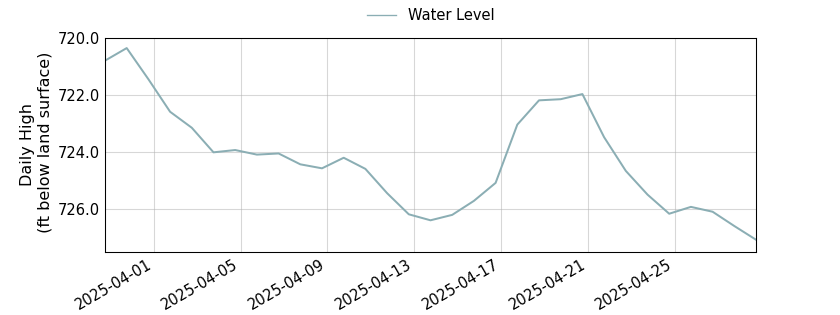
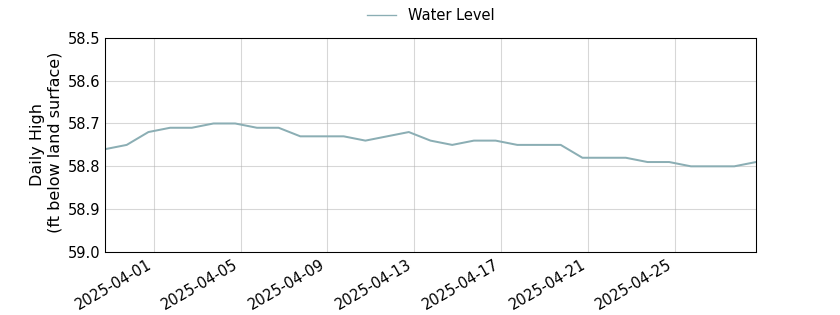
Interactive
Well Map

Bell County Monitor Wells

The District has a monitor well program that tracks water level measurements in numerous wells throughout Bell County. Water levels in wells are captured using different tools and resources to effectively gather a wide range of data throughout the District. 

The District’s most advanced monitoring system includes the use of a continuous monitoring Well Watch device from Eno Scientific which captures real time water levels and transmits the data via SignalFire telemetry directly into our database. This advanced system captures invaluable data when it comes to monitoring and tracking changes in water levels. Our database tools allow District staff to visualize this data over time and see water levels in relation to the screened intervals of the well and the aquifer.  

The majority of monitor well water levels are measured by hand on a quarterly basis by District staff. These measurements capture the static water level in the well using a sonic wave meter or an e-line. The static water level is the distance from ground level down to the top of the water in the well. Static is the resting level of water — i.e. when the pump is not actively pumping and hasn’t pumped recently. When pumping, the water level changes as the well fills back up to the static level. The speed at which the well refills – e.g. three gallons per minute – is called the recovery rate.

The remainder of the monitor wells are operated in coordination with the Texas Water Development Board (TWDB). The District pulls data from 12 TWDB wells that are located within Bell County and 4 additional wells located just outside of the District. 

Additional water levels are reported by water supply corporations with with meter readings and collected from all newly constructed wells in Bell County during well inspections. 

Total District Monitor Wells
0

TWDB Water Level Data in Bell County

All data are provisional and subject to revision. The Texas Water Development Board (TWDB) specifically disclaims any and all liability for any claims or damages that may result from providing these data. For additional information, including water level and water quality data, search the TWDB Groundwater Database (GWDB).

Copperas Cove Middle Trinity

Monitor well #4057601 is located on Boys Ranch Road outside of Killeen, Texas. It is 469 feet deep with a land elevation of 1,009 feet and monitors the middle (Hensell) formation of the Trinity aquifer in the Southwest management zone.

Deep
0 ft
Land Elevation
0 ft
Copperas Cove Middle Trinity Water Level

Monitor well #4057602 is located on Boys Ranch Road outside of Killeen, Texas. It is 629 feet deep with a land elevation of 1,009 feet and monitors the lower (Hoston) formation of the Trinity aquifer in the Southwest management zone.

Deep
0 ft
Land Elevation
0 ft
Copperas Cove Lower Trinity Water Level

Monitor well #5804702 is located on FM 2843 west of Salado, Texas. It is 95 feet deep with a land elevation of 730 feet and monitors the Edwards BFZ aquifer in the Stillhouse Hollow management zone.

Deep
0 ft
Land Elevation
0 ft
Patterson’s Crossing Edwards (Balcones Fault Zone) Water Level

Monitor well #4058201 is located on the Central Texas College campus in Killeen, Texas. It is 435 feet deep with a land elevation of 922 feet and monitors the upper (Glen Rose) formation of the Trinity aquifer in the Belton Lake management zone.

Deep
0 ft
Land Elevation
0 ft
Central Texas College Upper Trinity Water Level

Monitor well #5804628 is located adjacent to the Salado Cemetary in Salado, Texas. It is 129 feet deep with a land elevation of 662 feet and monitors the Edwards BFZ aquifer in the southern portion of Bell County.

Deep
0 ft
Land Elevation
0 ft
Salado Cemetery Edwards (Balcones Fault Zone) Water Level

Monitor well #5804816 is located at the rest stop outside of Salado, Texas. It is 170 feet deep with a land elevation of 735 feet and monitors the Edwards BFZ aquifer in the southern portion of Bell County.

Deep
0 ft
Land Elevation
0 ft
TxDOT South Bound Rest Area Salado Edwards (Balcones Fault Zone) Water Level

Monitor well #4061509 is located on South Pea Ridge Road in Temple, Texas. It is 1,261 feet deep with a land elevation of 518 feet. The well is owned by the City of Temple and monitors the lower (Hosston) formation of the Trinity aquifer in the Belton Lake management Zone.

Deep
0 ft
Land Elevation
0 ft
Pea Ridge Lower Trinity Water Level

Monitor well #4062501 is located on Barnhardt Road at the intersection of State Highway 95 and US Highway 190 in Temple, Texas. It is 2,236 feet deep with a land elevation of 623 feet and monitors the lower (Hosston) formation of the Trinity aquifer in the Eastern management zone.

Deep
0 ft
Land Elevation
0 ft
Acres Road Lower Trinity Water Level

Monitor well #5802303 is located in the River Ridge Ranch subdivision in Killeen, Texas. It is 637 feet deep with a land elevation of 817 feet and monitors the lower (Hosston) formation of the Trinity aquifer in the Southwest management zone.

Deep
0 ft
Land Elevation
0 ft
River Ridge Ranch Lower Trinity Water Level

Monitor well #5802304 is located in the River Ridge Ranch subdivision in Killeen, Texas. It is 467 feet deep with a land elevation of 815 feet and monitors the middle (Hensell) formation of the Trinity aquifer in the Southwest management zone.

Deep
0 ft
Land Elevation
0 ft
River Ridge Ranch Middle Trinity Water Level

Monitor well #5803701 is located on the Bell and Williamson County line in Florence, Texas. It is 880 feet deep with a land elevation of 987 feet and monitors the middle (Hensell) formation of the Trinity aquifer in the Southwest management zone.

Deep
0 ft
Land Elevation
0 ft
Gault Site Middle Trinity Water Level

Monitor well #5803702 is located on the Bell and Williamson County line in Florence, Texas. It is 110 feet deep with a land elevation of 984 feet and monitors the Edwards BFZ aquifer in the western portion of Bell County.

Deep
0 ft
Land Elevation
0 ft
Gualt Site Edwards (Balcones Fault Zone) Water Level