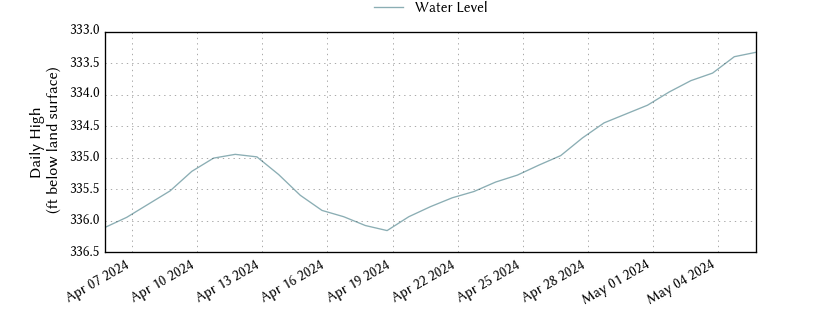
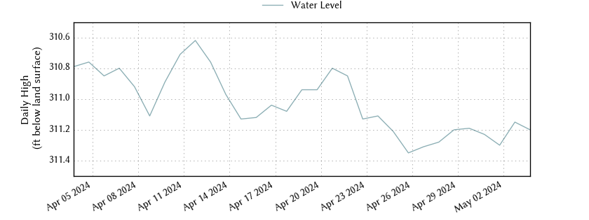
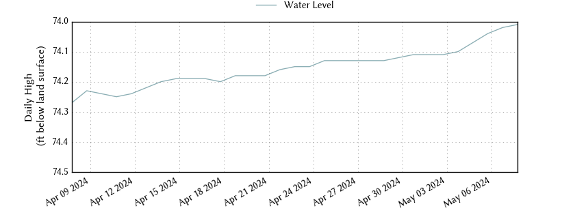
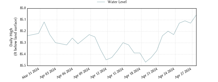
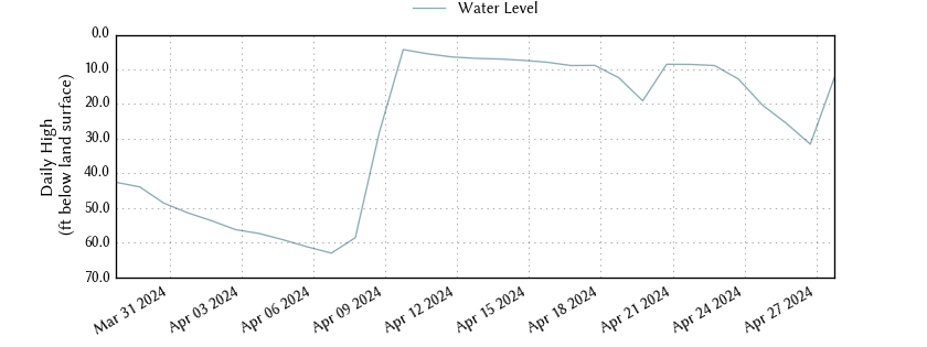
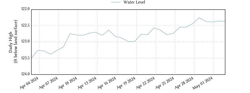
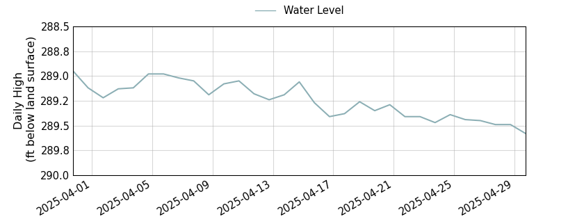
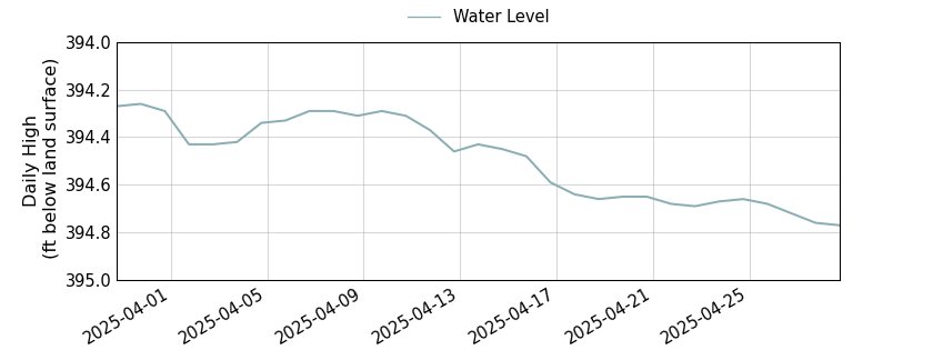
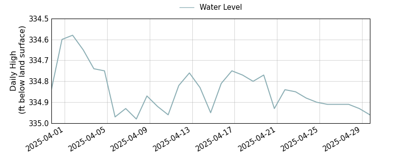
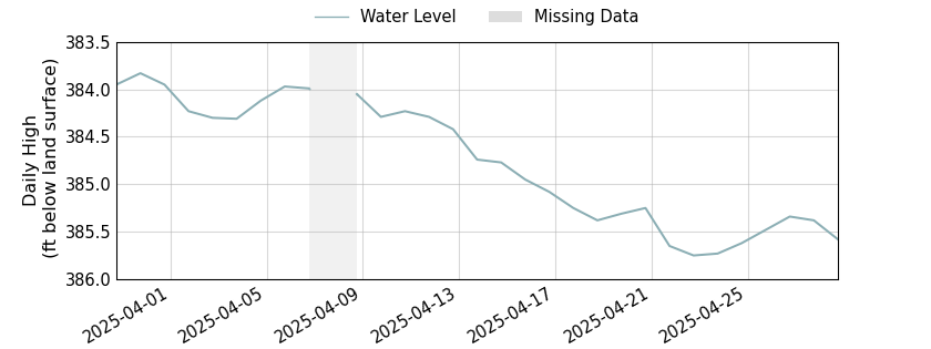
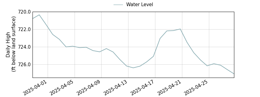
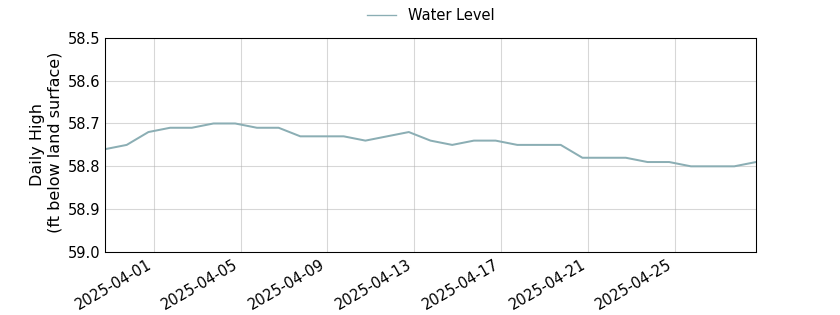
Interactivo
Mapa del pozo

Pozos de monitoreo del condado de Bell

The District monitors the static water level of numerous wells throughout Bell County quarterly in order to closely monitor the aquifer levels as part of our statutory responsibility.

A static water level (often simply called “the water level”) is the distance from ground level down to the water in the well. The meaning of “static” is the normal “resting” level of water — i.e. when the pump is not actively pumping and hasn’t pumped recently. If you have pumped, the water level changes as the well fills back up to the static level. The speed at which your well refills – e.g. three gallons per minute – is called your “Recovery Rate”.

All data are provisional and subject to revision. The Texas Water Development Board (TWDB) specifically disclaims any and all liability for any claims or damages that may result from providing these data. For additional information, including water level and water quality data, search the TWDB Groundwater Database (GWDB).

Copperas Cove Middle Trinity

Monitor well #4057601 is located on Boys Ranch Road outside of Killeen, Texas. It is 469 feet deep with a land elevation of 1,009 feet and monitors the middle (Hensell) formation of the Trinity aquifer in the Southwest management zone.

Deep
0 pie
Land Elevation
0 pie
Copperas Cove Middle Trinity Water Level

Monitor well #4057602 is located on Boys Ranch Road outside of Killeen, Texas. It is 629 feet deep with a land elevation of 1,009 feet and monitors the lower (Hoston) formation of the Trinity aquifer in the Southwest management zone.

Deep
0 pie
Land Elevation
0 pie
Copperas Cove Lower Trinity Water Level

Monitor well #5804702 is located on FM 2843 west of Salado, Texas. It is 95 feet deep with a land elevation of 730 feet and monitors the Edwards BFZ aquifer in the Stillhouse Hollow management zone.

Deep
0 pie
Land Elevation
0 pie
Patterson’s Crossing Edwards (Balcones Fault Zone) Water Level

Monitor well #4058201 is located on the Central Texas College campus in Killeen, Texas. It is 435 feet deep with a land elevation of 922 feet and monitors the upper (Glen Rose) formation of the Trinity aquifer in the Belton Lake management zone.

Deep
0 pie
Land Elevation
0 pie
Central Texas College Upper Trinity Water Level

Monitor well #5804628 is located adjacent to the Salado Cemetary in Salado, Texas. It is 129 feet deep with a land elevation of 662 feet and monitors the Edwards BFZ aquifer in the southern portion of Bell County.

Deep
0 pie
Land Elevation
0 pie
Salado Cemetery Edwards (Balcones Fault Zone) Water Level

Monitor well #5804816 is located at the rest stop outside of Salado, Texas. It is 170 feet deep with a land elevation of 735 feet and monitors the Edwards BFZ aquifer in the southern portion of Bell County.

Deep
0 pie
Land Elevation
0 pie
TxDOT South Bound Rest Area Salado Edwards (Balcones Fault Zone) Water Level

Monitor well #4061509 is located on South Pea Ridge Road in Temple, Texas. It is 1,261 feet deep with a land elevation of 518 feet. The well is owned by the City of Temple and monitors the lower (Hosston) formation of the Trinity aquifer in the Belton Lake management Zone.

Deep
0 pie
Land Elevation
0 pie
Pea Ridge Lower Trinity Water Level

Monitor well #4062501 is located on Barnhardt Road at the intersection of State Highway 95 and US Highway 190 in Temple, Texas. It is 2,236 feet deep with a land elevation of 623 feet and monitors the lower (Hosston) formation of the Trinity aquifer in the Eastern management zone.

Deep
0 pie
Land Elevation
0 pie
Acres Road Lower Trinity Water Level

Monitor well #5802303 is located in the River Ridge Ranch subdivision in Killeen, Texas. It is 637 feet deep with a land elevation of 817 feet and monitors the lower (Hosston) formation of the Trinity aquifer in the Southwest management zone.

Deep
0 pie
Land Elevation
0 pie
River Ridge Ranch Lower Trinity Water Level

Monitor well #5802304 is located in the River Ridge Ranch subdivision in Killeen, Texas. It is 467 feet deep with a land elevation of 815 feet and monitors the middle (Hensell) formation of the Trinity aquifer in the Southwest management zone.

Deep
0 pie
Land Elevation
0 pie
River Ridge Ranch Middle Trinity Water Level

Monitor well #5803701 is located on the Bell and Williamson County line in Florence, Texas. It is 880 feet deep with a land elevation of 987 feet and monitors the middle (Hensell) formation of the Trinity aquifer in the Southwest management zone.

Deep
0 pie
Land Elevation
0 pie
Gault Site Middle Trinity Water Level

Monitor well #5803702 is located on the Bell and Williamson County line in Florence, Texas. It is 110 feet deep with a land elevation of 984 feet and monitors the Edwards BFZ aquifer in the western portion of Bell County.

Deep
0 pie
Land Elevation
0 pie
Gualt Site Edwards (Balcones Fault Zone) Water Level